ARPSN Recorded Earthquake Collection
2010
Although there are many, constant, Seismic events; the following collection caught my 'amateur' attention, and are presented for observation & consideration:
Magnitude 6.5 - OFFSHORE NORTHERN CALIFORNIA
2010 January 10 00:26:38 UTC
http://earthquake.usgs.gov/earthquakes/recenteqsww/Quakes/nc71338066.php


Magnitude 6.5 Earthquake Rattles Eureka in Northern California
Local Seismic Activity 201003.02 20:05:33


100302.20200533csb2.psn 03/02/10 20:05:33 Cobb, CA E/W


100302.202042csb1.psn 03/02/10 20:20:42 Cobb, CA N/S

Locations of earthquakes in Iceland in the last 48 hours - 201003.04
http://hraun.vedur.is/ja/englishweb/index.html
Eyjafjallajökull - Earthquake Swarms and Possible Volcanic Activity
by C. Spangler, 201003.04 [Note: This note was written for another page and placed here for reference.]
Every once in a while I feel it is important to share what I am currently 'watching' ...and perhaps spawn new learning experience.
On a daily basis, I check out heliplots (seismic charts) provided by fellow members of PSN (Public Seismic Network) and have been watching seismic activity in Iceland because of my interest in Swarms.
Hekla PSN Station, located on Hvammstangi, Iceland
http://www.simnet.is/jonfr500/earthquake/tremoren.htm
While reading the morning news I discovered Erik Klemetti had 'bumped' the subject on his Eruptions page:
Increasing signs of activity at Eyjafjallajökull in Iceland
http://scienceblogs.com/eruptions/2010/03/increasing_signs_of_activity_a.php
which is (imo) an excellent read and enhancement for understanding my current interest.
Cobb, CA, 95426 - 201003.05 11:50:22 UTC Earthquakes

Cobb, CA 95426 - 201003.05 11:50:22 N/S FFT of Earthquake - Located at Anderson Springs, CA
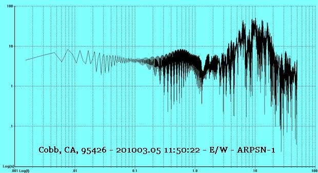
Cobb, CA 95426 - 201003.05 11:50:22 E/W FFT of Earthquake - Located at Anderson Springs, CA
Recent Local Seismic Activity - Magnitude 3.1
![Local Cobb [Mountain] CA 95426 USA Seismic Activity 201003.15 FFT N/S magnitude 3.1](../images/20100315fft132602csb1psn.jpg "Local Cobb [Mountain] CA 95426 USA Seismic Activity 201003.15 FFT N/S magnitude 3.1 - Open local seismic heliplots in new tab or window")
201003.15 13:26:02 UTC - Cobb [Mountain] CA 95426 USA
Iceland volcano eruption triggers fears for glacier
A volcano that has been dormant for almost 200 years has erupted in Iceland
by Our Foreign Staff, telegraph.co.uk,
Published: 9:42AM GMT 21 Mar 2010
Authorities evacuated hundreds of people after a volcano erupted beside a glacier in southern Iceland, Iceland's civil protection agency said on Sunday, but there were no immediate reports of damage or injuries.
The eruption occurred beside the Eyjafjallajokull glacier, the fifth largest in Iceland. Authorities initially said the eruption was below the glacier, triggering fears that it could lead to flooding from glacier melt, but scientists conducting an aerial survey in daylight located the eruption and said it did not occur below ice.
"The eruption is a small one," said Agust Gunnar Gylfason, a risk analyst at the Civil Protection Department.
"An eruption in and close to this glacier can be dangerous due to possible flooding if the fissure forms under the glacier," he said.
"That is why we initiated our disaster response plan."
The last time the volcano erupted was in the 1820s.
Scientists can see lava flows in the half-mile long fissure, and authorities are watching for further activity.
Authorities evacuated some 450 people in the area 100 miles southeast of the capital,Reykjavik, as a precaution, said Vidir Reynisson, the department manager for the Icelandic Civil Protection Department.
A state of emergency has been declared in communities near the 100 square mile glacier, and three Red Cross centers were set up for evacuees in the village of Hella.
The Icelandic Civil Aviation Administration has ordered aircraft to stay 120 nautical miles away from the volcano area, essentially closing it off.
Three Icelandair flights from the U.S. - departing from Seattle; Boston; and Orlando, Florida - bound for Keflavik airport in Reykjavik were turned back to Boston. All domestic flights were also canceled until further notice, the Icelandic National Broadcasting Service reported.
Keflavik international airport, Reykjavik airport and Akureyri airport are all closed due to the possibility of ash getting into engines of the planes. The only airport that is open is Egilsstadir airport in the eastern part of the country as a back up international airport.
Gudjon Arngrimsson, a spokesman for Icelandair, said he could not immediately comment.
A European volcanic island in the North Atlantic, Iceland is largely an arctic desert with mountains, glaciers and volcanoes and agricultural areas in the lowlands close to the coastline.
Of Interest, Magnitude 2.5 & Above, Only:
Date Posted: 201003.19 Updated: 201003.26 - Source
Mag * UTC DATE-TIME, y/m/d h:m:s * LAT deg * LON deg * DEPTH km * Region
MAP 3.1 2010/03/19 06:25:02 18.800 -64.182 34.2 VIRGIN ISLANDS REGION
MAP 2.7 2010/03/18 20:54:03 18.905 -65.194 4.5 PUERTO RICO REGION
MAP 2.9 2010/03/18 16:19:05 18.899 -65.862 33.7 PUERTO RICO REGION
MAP 2.5 2010/03/18 08:43:55 19.118 -66.503 19.7 PUERTO RICO REGION
MAP 2.7 2010/03/18 05:22:47 19.114 -66.521 24.9 PUERTO RICO REGION
MAP 2.7 2010/03/18 05:20:29 19.091 -66.545 24.9 PUERTO RICO REGION
MAP 3.0 2010/03/18 04:56:23 19.095 -66.521 24.9 PUERTO RICO REGION
MAP 2.6 2010/03/18 03:27:08 18.987 -66.491 6.3 PUERTO RICO REGION
MAP 2.8 2010/03/18 02:44:27 19.092 -66.510 25.1 PUERTO RICO REGION
MAP 3.1 2010/03/17 21:33:07 18.860 -64.631 1.0 VIRGIN ISLANDS REGION
MAP 3.0 2010/03/17 16:31:14 18.443 -66.472 86.8 PUERTO RICO
MAP 3.0 2010/03/17 13:48:21 18.984 -66.485 4.1 PUERTO RICO REGION
MAP 2.8 2010/03/17 13:16:46 19.056 -66.389 19.7 PUERTO RICO REGION
MAP 2.9 2010/03/17 12:02:35 19.056 -66.484 31.0 PUERTO RICO REGION
MAP 2.6 2010/03/17 11:45:08 19.094 -66.510 27.8 PUERTO RICO REGION
MAP 2.8 2010/03/17 10:35:46 19.107 -66.500 24.0 PUERTO RICO REGION
MAP 2.5 2010/03/17 10:32:56 19.089 -66.482 28.2 PUERTO RICO REGION
MAP 2.7 2010/03/17 09:50:39 19.002 -66.480 4.9 PUERTO RICO REGION
MAP 2.8 2010/03/17 09:42:51 19.090 -66.486 41.4 PUERTO RICO REGION
MAP 2.7 2010/03/17 09:26:01 19.095 -66.485 20.0 PUERTO RICO REGION
MAP 2.8 2010/03/17 09:23:42 19.060 -66.487 13.8 PUERTO RICO REGION
MAP 2.7 2010/03/17 09:19:15 19.113 -66.510 25.2 PUERTO RICO REGION
MAP 2.7 2010/03/17 08:55:34 19.032 -66.514 13.8 PUERTO RICO REGION
MAP 2.7 2010/03/17 08:49:47 19.072 -66.493 11.6 PUERTO RICO REGION
MAP 2.5 2010/03/17 08:47:17 19.103 -66.489 32.0 PUERTO RICO REGION
MAP 2.6 2010/03/17 08:45:58 19.090 -66.498 20.0 PUERTO RICO REGION
MAP 2.7 2010/03/17 08:44:57 19.072 -66.492 21.8 PUERTO RICO REGION
MAP 2.7 2010/03/17 08:42:21 19.092 -66.497 24.6 PUERTO RICO REGION
MAP 2.8 2010/03/17 08:40:30 19.117 -66.538 23.8 PUERTO RICO REGION
MAP 2.7 2010/03/17 08:34:36 19.102 -66.501 22.1 PUERTO RICO REGION
MAP 2.8 2010/03/17 08:32:00 19.083 -66.509 25.0 PUERTO RICO REGION
MAP 2.5 2010/03/17 08:31:22 19.081 -66.464 25.0 PUERTO RICO REGION
MAP 2.6 2010/03/17 08:27:28 19.015 -66.492 6.0 PUERTO RICO REGION
MAP 3.0 2010/03/17 08:23:18 19.080 -66.474 27.0 PUERTO RICO REGION
MAP 2.5 2010/03/17 08:20:42 18.995 -66.482 5.6 PUERTO RICO REGION
MAP 2.8 2010/03/17 08:15:54 19.054 -66.497 13.1 PUERTO RICO REGION
MAP 2.9 2010/03/17 08:14:34 19.170 -66.540 35.5 PUERTO RICO REGION
MAP 3.0 2010/03/17 08:12:24 19.092 -66.496 25.0 PUERTO RICO REGION
MAP 2.7 2010/03/17 08:08:57 19.092 -66.505 18.4 PUERTO RICO REGION
MAP 2.6 2010/03/17 08:06:39 18.968 -66.492 8.1 PUERTO RICO REGION
MAP 2.7 2010/03/17 08:03:58 19.050 -66.501 9.1 PUERTO RICO REGION
MAP 2.5 2010/03/17 07:59:05 19.000 -66.499 4.3 PUERTO RICO REGION
MAP 2.5 2010/03/17 07:55:15 19.087 -66.499 15.5 PUERTO RICO REGION
MAP 2.6 2010/03/17 05:17:00 18.998 -66.494 6.0 PUERTO RICO REGION
MAP 2.8 2010/03/17 04:27:29 19.011 -66.464 4.1 PUERTO RICO REGION
MAP 2.9 2010/03/17 03:02:24 19.068 -66.403 38.7 PUERTO RICO REGION
MAP 2.7 2010/03/16 22:23:05 18.986 -66.498 5.5 PUERTO RICO REGION
MAP 2.8 2010/03/16 21:52:43 18.995 -66.514 8.0 PUERTO RICO REGION
MAP 2.5 2010/03/16 15:22:57 18.638 -65.052 13.8 VIRGIN ISLANDS REGION
MAP 3.3 2010/03/16 08:11:33 19.355 -65.668 6.3 PUERTO RICO REGION
MAP 2.8 2010/03/16 07:40:04 17.999 -68.282 79.4 DOMINICAN REPUBLIC REGION
MAP 2.9 2010/03/16 05:46:50 18.950 -64.338 23.1 VIRGIN ISLANDS REGION
MAP 4.6 2010/03/16 00:09:36 19.579 -75.827 10.0 CUBA REGION
MAP 4.1 2010/03/15 17:25:48 18.769 -69.669 104.0 DOMINICAN REPUBLIC
MAP 3.1 2010/03/15 09:36:32 19.031 -65.475 18.7 PUERTO RICO REGION
MAP 3.2 2010/03/15 09:11:40 19.022 -65.496 4.8 PUERTO RICO REGION
MAP 2.9 2010/03/15 09:10:43 18.971 -65.476 41.2 PUERTO RICO REGION
MAP 2.8 2010/03/15 09:08:06 18.983 -65.472 43.2 PUERTO RICO REGION
MAP 2.5 2010/03/15 06:59:34 18.382 -67.712 6.3 MONA PASSAGE, PUERTO RICO
MAP 2.7 2010/03/15 05:01:13 18.889 -66.341 61.2 PUERTO RICO REGION
MAP 3.0 2010/03/15 04:57:33 19.127 -66.403 25.6 PUERTO RICO REGION
MAP 2.9 2010/03/15 01:19:33 19.112 -66.417 28.1 PUERTO RICO REGION
MAP 2.9 2010/03/14 20:06:46 18.116 -65.372 4.0 PUERTO RICO REGION
MAP 2.7 2010/03/14 09:26:16 18.416 -64.987 42.2 VIRGIN ISLANDS REGION
MAP 4.6 2010/03/14 02:52:55 12.849 -88.755 76.3 OFFSHORE EL SALVADOR
MAP 3.0 2010/03/14 00:54:01 18.790 -64.732 112.1 VIRGIN ISLANDS REGION
MAP 2.8 2010/03/13 20:43:26 18.188 -66.151 77.5 PUERTO RICO
MAP 3.3 2010/03/13 11:03:50 18.995 -66.365 45.4 PUERTO RICO REGION
MAP 2.6 2010/03/13 03:23:16 18.830 -68.801 27.3 DOMINICAN REPUBLIC
MAP 3.0 2010/03/12 16:49:06 18.115 -65.431 2.7 ISLA DE VIEQUES, PUERTO RICO
My interest declined when the following events occurred:
MAP 4.8 2010/03/20 19:31:29 19.835 -75.290 10.0 CUBA REGION
MAP 4.4 2010/03/20 18:38:23 19.818 -75.367 10.0 CUBA REGION
MAP 5.6 2010/03/20 18:08:10 19.720 -75.287 16.6 CUBA REGION
My interest is picking up again:
MAP 6.0 2010/03/25 05:29:25 13.825 120.072 16.0 MINDORO, PHILIPPINES
MAP 2.5 2010/03/25 11:25:33 18.824 -67.343 10.0 PUERTO RICO REGION
MAP 3.0 2010/03/25 13:55:34 19.708 -64.522 16.1 VIRGIN ISLANDS REGION
MAP 2.8 2010/03/25 17:07:15 17.880 -65.208 11.8 PUERTO RICO REGION
MAP 2.8 2010/03/26 01:41:16 17.873 -66.521 8.1 PUERTO RICO REGION
MAP 2.7 2010/03/26 01:33:25 17.916 -66.514 12.8 PUERTO RICO REGION
MAP 3.4 2010/03/26 00:41:37 19.285 -65.946 81.0 PUERTO RICO REGION
MAP 3.5 2010/03/26 14:34:19 19.440 -65.953 15.0 PUERTO RICO REGION
At this point, although it was not included, there was another "floating swarm" that appeared in the VIRGIN ISLANDS REGION that was followed by the magnitude 7.2 in Baja:
MAP 7.2 2010/04/04 22:40:41 32.128 -115.303 10.0 BAJA CALIFORNIA, MEXICO
and it will be interesting, in the future, to see if this particular type of "floating swarm" pattern will produce another sizable earthquake in, perhaps, the Southern California area ???

Eyjafjallajökull Volcano, Iceland
Iceland Volcanic Activity - 201004.02 1350 UTC
Eyjafjallajökull frá Þórólfsfelli

http://eldgos.mila.is/eyjafjallajokull-fra-thorolfsfelli/

Eyjafjallajökull frá Þórólfsfelli, Iceland - 201004.07 13:45 UTC
Iceland - Útsýni frá Fimmvörðuhálsi

http://eldgos.mila.is/eyjafjallajokull-fra-fimmvorduhalsi/
USGS: Northern CA temblor unrelated to Baja quake
SAN FRANCISCO — A geophysicist with the U.S. Geological Survey says an earthquake recorded Sunday afternoon in Northern California was not related to a quake that hit south of the U.S.-Mexico border earlier in the day.
The USGS says the Northern California quake, with a magnitude of 4.0, hit about 25 miles north of Santa Rosa at 3:49 p.m.
Geophysicist Rafael Abreu described the Northern California quake as "typical seismic behavior" for the area.
A dispatcher with the Sonoma County Sheriff's Department, in Santa Rosa, says he didn't feel the temblor and the department hasn't received any calls for service related to the quake.
Santa Rosa is about 50 miles north of San Francisco.
THIS IS A BREAKING NEWS UPDATE. Check back soon for further information. AP's earlier story is below.
SAN FRANCISCO (AP) — An earthquake with a preliminary magnitude of 4.0 has been recorded in Northern California.
The U.S. Geological Survey says the quake hit at 3:49 p.m. Sunday about 25 miles north of Santa Rosa. Santa Rosa is about 50 miles north of San Francisco.
The area frequently experiences small earthquakes, and there was no indication the earthquake was an aftershock from the larger quake that struck in Baja California, Mexico, on Sunday afternoon.
A dispatcher with the Sonoma County Sheriff's Department in Santa Rosa said he didn't feel the quake and that the department had not received any calls for service after the quake.
ARPSN-1 Cobb [Mountain] CA Seismic Heliplots
20100404 22:48:09 UTC - 15:48:09 PDT
PSN DATA: 100404.224809.csb1.psn - 100404.224809.csb2.psn [Info: WinQuake files]
![ARPSN-1 Cobb [Mountain] CA 95426 Raw Data 20100404 22:48:09 UTC](../images/20100404cobbraw.jpg "ARPSN-1 Cobb [Mountain] CA 95426 Raw Data 20100404 22:48:09 UTC")
ARPSN-1 Cobb [Mountain] CA 95426 Raw Data 20100404 22:48:09 UTC
![ARPSN-1 Cobb [Mountain] CA 95426 North/South 20100404 22:48:09 UTC](../images/20100404cobbns.jpg "ARPSN-1 Cobb [Mountain] CA 95426 North/South 20100404 22:48:09 UTC")
ARPSN-1 Cobb [Mountain] CA 95426 North/South 20100404 22:48:09 UTC
![ARPSN-1 Cobb [Mountain] CA 95426 North/South FFT 20100404 22:48:09 UTC](../images/20100404cobbnsfft.jpg "ARPSN-1 Cobb [Mountain] CA 95426 North/South FFT 20100404 22:48:09 UTC")
ARPSN-1 Cobb [Mountain] CA 95426 North/South FFT 20100404 22:48:09 UTC
![ARPSN-1 Cobb [Mountain] CA 95426 East/West 20100404 22:48:09 UTC](../images/20100404cobbew.jpg "ARPSN-1 Cobb [Mountain] CA 95426 East/West 20100404 22:48:09 UTC")
ARPSN-1 Cobb [Mountain] CA 95426 East/West 20100404 22:48:09 UTC
![ARPSN-1 Cobb [Mountain] CA 95426 East/West FFT 20100404 22:48:09 UTC](../images/20100404cobbewfft.jpg "ARPSN-1 Cobb [Mountain] CA 95426 East/West FFT 20100404 22:48:09 UTC")
ARPSN-1 Cobb [Mountain] CA 95426 East/West FFT 20100404 22:48:09 UTC
ARPSN sensors are connected to (individual) Garmin GPS. Logs show 9 satellites "(L)ocked" during the above L15B recordings and the (imo) 'more interesting' VM sensor recordings are not available on-line, at this time.
USGS says NorCal quake report wrong after review
THE GEYSERS, Calif. — Seismologists have canceled a report of a magnitude-4.0 earthquake in Northern California after a review of the data.
Seismologist Susan Potter says a preliminary report from the U.S. Geological survey showed that a quake struck about 25 miles north of Santa Rosa in the hour after a much larger quake shook Mexico and Southern California, but the report was deleted hours later.
It was not immediately clear why the false report was generated, but large temblors can often produce faulty readings in distant areas.
Potter says a swarm [Something I call: floating swarm.] of small earthquakes has shaken the area, but none have been larger than magnitude-2.3. - Copyright © 2010 The Associated Press. All rights reserved.


USGS - Cobb, CA 2010/04/04 22:48:44 UTC - 201004.10 Downgraded to 2.2
201004.10 - Magnitude - 3.1 The Geysers

Magnitude -
3.1 The Geysers - April 10, 2010 - 5:26:26 AM PDT - USGS

ARPSN-1 Cobb [Mountain] CA 95426 - 201004.10 12:24:58 UTC - Raw Data

ARPSN-1 Cobb [Mountain] CA 95426 North/South 201004.10 12:24:58 UTC

ARPSN-1 Cobb [Mountain] CA 95426 North/South 201004.10 12:24:58 UTC - FFT
Spain hit by 6.3 magnitude earthquake
Sunday, April 11, 2010, Wikinews
The USGS has reported a 6.3 magnitude earthquake in Spain. It had a depth of 616.7 kilometers. The epicenter was located 25 kilometers northeast from Granada, 106 kilometers northwest of Málaga and 341 kilometers south of Madrid. It occurred on Monday at 00:08:10 local time (22:08:10 UTC).
People posted via Twitter that the earthquake was felt in Cádiz, Málaga, and Murcia.
CNN reports there are no immediate reports of deaths, injuries or damages. "An earthquake with that depth means little damage is likely," seismologist Susan Potter told CNN. "When an earthquake is deeper, the seismic energy is absorbed by the Earth, so there will be less damage expected in the epicenter area," she said too.
Meanwhile, almost a month ago, on March 1, the Spanish Geologist Luis Eugénio Suarez, said that the Granada area could suffer an earthquake within the short term, and with an intensity similar to that of the February 27 Cauquenes, Chile earthquake. Suárez commented that "Spain is not like Chile," because the latter is located on a high seismic frequency area, but also noted that "once every hundred years, a destructive earthquake is produced in the peninsula."
The last earthquake in Spain was in Arenas del Rey, in Granada, 126 years ago, and reached a magnitude of 6.6, leaving between 750 and 900 dead, thousands injured and material destruction.

Click for large image
Centre Sismologique Euro-Méditerranéen
European-Mediterranean Seismological Centre
http://www.emsc-csem.org/index.php?page=home
2010-04-11 22:08:11.5 37.07 N 3.51 W 623 Mw 6.3 SPAIN
Magnitude 6.3 - SPAIN - 2010 April 11 22:08:10 UTC - USGS
Historic Earthquakes Spain - USGS
1954 March 29 UTC - Magnitude 7.9 - Near the south of Spain.
This earthquake caused property damage at Malaga. Felt at Madrid, Granada and Cadiz, Spain; Tangier, Spanish Morocco, and Casablanca, French Morocco. The depth was 640 kilometers. - Abridged from United States Earthquakes, 1954.
HISTORICAL EARTHQUAKES IN THE SOUTH OF SPAIN
Instituto Andaluz de Geofísica - Period 880 - 1999 - English Translation
Recent [IAG] earthquakes felt in Andalusia [2010] - English Translation
Personal Interest Regarding this Earthquake: Depth = 623 km (387.1 miles)

2010/105 - 04/15 at 11 :35 UTC Ash plume from Eyjafjallajokull Volcano over the North Atlantic - Large Image
Eyjafjallajökull Volcano, Iceland, Erupts
Mýrdals- og Eyjafjallajökulsvöktun 2010
http://hraun.vedur.is/ja/Katla2009/
Iceland Volcano Erupts Under Glacier, Triggers Floods
Ker Than
for National Geographic News
Published April 14, 2010
After a brief respite, an Iceland volcano has erupted for a second time, but from a different, glacier-covered vent. Melting ice spurred an emergency nighttime evacuation of hundreds of people in the flood zone.
About 800 people living nearby were evacuated as a precautionary measure at the first signs of the second eruption, said Páll Einarsson, a geophysicist at the University of Iceland's Institute of Earth Sciences. There are no reports of casualties so far.
But initial reports suggest glacial melt from Iceland's Eyjafjallajökull volcano, located about 75 miles (120 kilometers) from Reykjavik, has raised local rivers by as much as ten feet (three meters).
A major road has been closed and, as of press time, water continues to gush into the ocean.
Iceland Volcano Still Active
Eyjafjallajökull first erupted on March 20, 2010, in a fiery display that sent fountains of lava shooting high into the air and ribbons of lava flowing down cliff faces. (See pictures of the initial Iceland volcano eruption.)
That eruption, the volcano's first in nearly 200 years, opened up new vents nearby and built a 27-story-tall cone of magmatic rock.
After an initial evacuation of nearby villages in March, flooding fears subsided and the Iceland volcano quickly became a popular tourist attraction. (Iceland Volcano Pictures: Eruption Sparks Tourist Boom.)
As of April 13, Eyjafjallajökull's eruption seemed to be quieting down. But just hours later another eruption broke out on another part of the volcano.
"It's still going on, and probably still increasing at the moment," Einarsson said.
Steep Volcano = Fast Floodwaters
The initial series of eruptions did not trigger flooding, because the active vents were in a mostly ice-free part of the landscape, Einarsson explained. (See aerial pictures of the Iceland volcano.)
By contrast, the current eruption started beneath a 650-foot-thick (200-meter-thick) block of ice. Heat from the eruption quickly transformed the glacier into a fast-flowing torrent of water.
"The volcano is quite steep, so the floodwater comes down rather powerfully in a short time," Einarsson said. "We were nervous that we would not be able to evacuate people in time, but this was quite successful."
Another danger associated with Eyjafjallajökull's eruption is that it could agitate a neighboring volcano, called Katla, which sits about 12 miles (20 kilometers) away.
"Historically," Einarsson said, "the eruption of [Eyjafjallajökull] has triggered the eruption of Katla."
![]() Apple QuickTime Movie
Apple QuickTime Movie
Flash Size: 884,499 * QuickTime Size: 5,843,059
![]() Apple QuickTime Movie
Apple QuickTime Movie
Flash Size: 1,255,402 * QuickTime Size: 6,870,078
![]() Apple QuickTime Movie
Apple QuickTime Movie
Flash Size: 1,829,485 * QuickTime Size: 7,380,531
Source: http://eldgos.mila.is/eyjafjallajokull-fra-valahnjuk/
[Ed. Note: When I sit down to do the 'stuff' one sees here, I turn on iTunes music in the background, which is set for random play. The first tune to come up was "Eruption" by (early) Van Halen and that inspired the above short videos.]

Eyjafjallajökull Volcano - Local History
March 04, 2010 - Eyjafjallajökull - Earthquake Swarms and Possible Volcanic Activity
March 21, 2010 - Iceland volcano eruption triggers fears for glacier
March 22, 2010 - The steam-and-ash plume from Eyjafjallajokull in Iceland
March 25, 2010 - Eyjafjallajökull Volcano Web cam image
April 02, 2010 - Eyjafjallajökull Web cam images
April 07, 2010 - Eyjafjallajökull Web cam images
April 14, 2010 - Eyjafjallajökull Volcano, Iceland, Erupts
The Eyjafjallajökull volcano activity was an observation that had nothing to do with prediction!
My main interest is, 'early detection' of earthquakes, and my secondary interest is Swarms related to volcanic activity; more specifically, [what I call] "Floating Swarms," that have nothing to do with volcanic activity. My other interests are, currently, teleseismic events and HUM.
Floating Swarms suggest a possible path to 'early detection' based on 'specific sets' of eigenmode frequencies appearing in 'specific patterns' and this link will provide 'some' information, regarding research, on this project.
Of Personal Interest, May 2, 2010
Date Posted: 2010054.02:
MAP 4.6 2010/05/02 01:47:40 -17.748 -178.610 561.7 - FIJI REGION
MAP 4.7 2010/05/02 06:28:46 -17.910 -178.655 590.0 - FIJI REGION
MAP 4.6 2010/05/02 09:17:28 73.802 8.720 10.0 - GREENLAND SEA
MAP 4.2 2010/05/02 12:24:38 35.809 24.516 48.8 - CRETE, GREECE
MAP 4.6 2010/05/02 14:09:20 -23.338 -179.854 540.9 - SOUTH OF THE FIJI ISLANDS

Eyjafjallajökull - Iceland Volcano Activity 201005.02 - 15:05 UTC - Webcam
Seismic Activity Of Personal Interest
201005.07 20:00:00 UTC
Here is what caught my attention first (yesterday):
MAP 4.5 2010/05/06 23:12:33 48.326 -127.847 10.0 VANCOUVER ISLAND, CANADA REGION
and here is what caused this post (today):
MAP 4.5 2010/05/07 17:09:05 -24.029 179.784 614.3 SOUTH OF THE FIJI ISLANDS
MAP 5.1 2010/05/07 17:46:15 44.396 -129.437 10.0 OFF THE COAST OF OREGON
MAP 4.4 2010/05/07 18:41:55 44.407 -129.456 10.0 OFF THE COAST OF OREGON
MAP 4.5 2010/05/07 18:43:09 44.456 -129.410 10.0 OFF THE COAST OF OREGON
MAP 3.9 2010/05/07 18:48:38 44.458 -129.107 10.0 OFF THE COAST OF OREGON
MAP 4.2 2010/05/07 18:51:01 44.490 -129.557 10.0 OFF THE COAST OF OREGON
MAP 4.4 2010/05/07 18:55:05 44.508 -130.052 10.0 OFF THE COAST OF OREGON
MAP 4.3 2010/05/07 19:03:32 44.536 -129.557 10.0 OFF THE COAST OF OREGON
MAP 3.9 2010/05/07 19:15:59 44.527 -130.659 10.0 OFF THE COAST OF OREGON
MAP 4.4 2010/05/07 20:02:20 44.496 -129.418 10.0 OFF THE COAST OF OREGON
MAP 7.2 2010/05/09 05:59:43 3.775 96.055 45.0 NORTHERN SUMATRA, INDONESIA
For Personal Reference Only 201005.17
There are a similar set of 'patterns' that caused this posting happening; however, there is something new, for me, as, there are 2 extra 'things', where they do not belong, and any 'new' 'swarm' activity (Alaska) would raise my interest.
I do not have time to list the earthquakes, at this moment, so if one monitors this page, go to (dated) USGS World (dated) for verification.
![]()